


Digital terrain data are topographic data, including ground height or elevation, slope (gradient and slope aspect), types of slope etc., which are called DTM (Digital Terrain Model) or DEM (Digital Elevation Model).
Terrain features can be expressed using the following four methods.
1) Contour Lines.
Usually elevations on a topographic map are represented as a group of contour lines with a discrete and constant contour interval.
2) Grid data.
For convenience of computer processing, a set of grid data with elevation are acquired from contour maps, aerial photographs or stereo satellite image data, as shown in Figure 6.10.1. Terrain data other than the grid data are interpolated from the surrounding grid data.
3) Random point data.
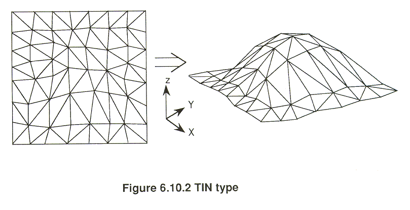
Terrain features are sometimes represented by a group of randomly located terrain data with three dimensional coordinates. For computer processing, random point data are converted to triangulated irregular network (TIN) as shown in Figure 6.10.2. TIN has the advantage of easy control of point density according to the terrain feature, though it has the disadvantage of being time consuming in the random search for the terrain point.
4) Surface function.
Terrain surface can be expressed mathematically as a surface function, for example, a Spline function.
A DEM can be generated by the following two methods.
1) Survey and photogrammetry
A ground survey is implemented using a total station, with a function of digital output, giving a high accuracy over a comparatively narrow area. Aerial photogrammetry can be executed by a digital plotter with a function of automated image matching. The digital 3D coordinates will be automatically generated. Stereo remote sensing data from space will be a powerful tool to produce 1:50,000 topographic maps in the near future.
2) DTM generation from contour maps
Contour lines are measured by a tablet digitizer manually, or by a scanner automatically or semi-automatically, to generate the DEM.
The DEM is used for generating a digital orthophotomap and a 3-D view as well, for terrain analysis in geomorphology and geological studies.
Copyright © 1996 Japan Association of Remote Sensing All rights reserved