


Remote sensing data involves many radiometric errors resulting from sensitivity of detector, atmospheric condition, alignment of detectors and so on. Calibration is defined as the correction of the observed data, or relationship, into physically meaningful data, or relationship, by using a reference. For example, calibration involves the correction of observed data into absolute irradiance, reflectance or actual temperature.
Calibration can be classified into two types; ground calibration and on-board calibration, as shown in Table 6.6.1. The ground calibration data are measured before launch with a halogen lamp for visible and reflective infrared, and a black body for thermal infrared, which are normally described in the User's Manual.
The on-board calibration data are obtained on board after launch with on board references such as lamp and blackbody as well as physically known or constant objects such as sunlight, shadows on the ground and space with low temperature. The on board calibration data are transmitted from the satellite to ground receiving stations, together with the image data.
Table 6.6.2 shows the three calibration levels; interband calibration, band-to-band calibration, and absolute calibration.
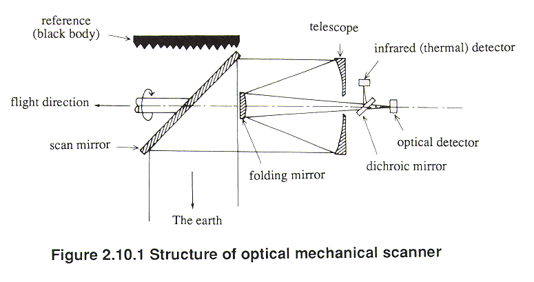
In the case of NOAA AVHRR data, the ground calibration data are used for calibrating visible and near infrared data, while on-board calibration data are used for calibrating thermal data. Twelve lamps provide the ground calibration data, by which image data can be converted to Albedo. Thermal data can be converted to brightness temperature with the two reference temperature data of space (-270  C) and black body (l5 C) measured by a platinum resistance thermometer (see Figure 2.10.1).
The brightness temperature obtained after calibration involves atmospheric influences. Therefore atmospheric correction is necessary. There are two types of atmospheric correction; a theoretical approach using an atmospheric model, and an empirical approach with ground truth data which are measured simultaneously with the satellite orbit.
In the latter case, so called validation data should be collected as ground data, for example, observed sea surface temperature from boats and buoys.
Validation is classified into three types; instrument specification, physical quantities and practical usages as shown in Table 6.6.3. Nevertheless, validation should be linked with ground data as explained in the next section 6.7.
Copyright © 1996 Japan Association of Remote Sensing All rights reserved