


Information extraction in remote sensing can be categorized into five types as shown in Table 7.1.1. Classification is a type of categorization of image data using spectral, spatial and temporal information. Change detection is the extraction of change between multi-date images. Extraction of physical quantities corresponds to the measurement of temperature, atmospheric constitutients, elevation and so on, from spectral or stereo information. Extraction of indices is the computation of a newly defined index, for example, the vegetation index (see 10.6) from satellite data. Identification of specific features is the identification, for example, of disaster, lineament, archaeological and other features, etc.
Information extraction can be made by human or computer methods. Information extraction by human interpretation will be described in the next sections, while information extraction by computer will be explained in chapter 8.
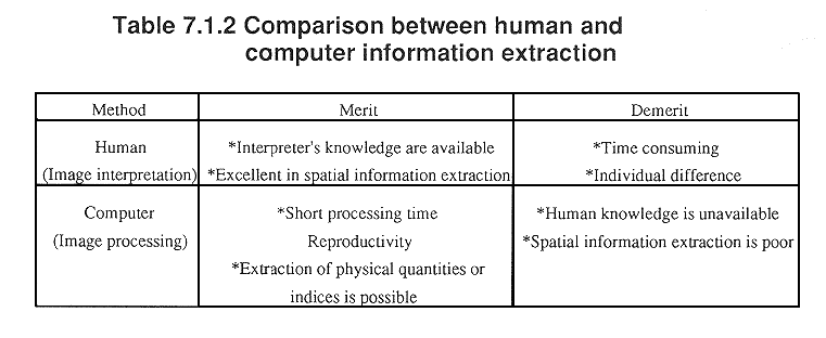
Table 7.1.2 provides a comparison between human and computer information extraction. As seen in the table, human and computer methods supplement each other, so that they both may offer better results when combined. For example in geology, computers will produce an enhanced image, from which humans can interpret the geological features.
A computer system with an interactive graphic display through which humans and computers can interactively work together is called "a man-machine interactive system".
Because human interpretation is time consuming, as well as expensive, a special computer technique, with the ability of human interpretation, is being developed. For example, an expert system is a computer software system with a training ability to use the interpreter's knowledge for information extraction.
Copyright © 1996 Japan Association of Remote Sensing All rights reserved