
| Table of Contents |
| 1. Introduction 2. Sensors 3. Microwaves 4. Image Analysis 5. Applications |
Fundamentals of Remote Sensing
1.7 Whiz Quiz
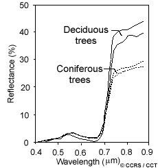
1. If you wanted to map the deciduous (e.g. maple, birch) and the coniferous (e.g. pine, fir, spruce) trees in a forest in summer using remote sensing data, what would be the best way to go about this and why? Use the reflectance curves illustrating the spectral response patterns of these two categories to help explain your answer.
The answer is ...
2. What would be the advantage of displaying various wavelength ranges, or channels, in combination as colour images as opposed to examining each of the images individually?
The answer is ...
![]()

![]()
| Updated2002-08-21 | Important Notices |