Natural Resources Canada | Ressources naturelles CanadaGovernment of Canada | Gouvernement du Canada
FrançaisContact CCRSCCRS Site HelpSearch the CCRS WebsiteGovernment of Canada web site
Canada Centre for Remote SensingHome page of the Canada Centre for Remote SensingDetailed Listing of this SiteTechnical publications of CCRS staffExplanations of remote sensing terminology.Natural Resources Canada
Staff and organizationCCRS research programsImages and SensorsLearning aids and reference materialsThe Canadian remote sensing community

Table of Contents
1. Introduction
2. Sensors
3. Microwaves
4. Image Analysis
5. Applications

Home > LearningTutorials

Fundamentals of Remote Sensing


Chapter 2 - Satellites and Sensors


2.3 Did You Know?

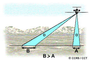
If the IFOV for all pixels of a scanner stays constant (which is often the case), then the ground area represented by pixels at the nadir will have a larger scale then those pixels which are off-nadir. This means that spatial resolution will vary from the image centre to the swath edge.

High wing aircraft

back to Section 2.3 Whiz Quiz 2.3 Section 2.4


Updated2002-08-21 go to top of page Important Notices