| Table of Contents |
| 1. Introduction 2. Sensors 3. Microwaves 4. Image Analysis 5. Applications |
Fundamentals of Remote Sensing
2.3 Whiz Quiz
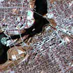
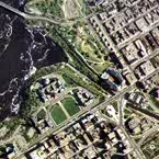
1. Look at the detail apparent in each of these two images. Which of the two images is of a smaller scale? What clues did you use to determine this? Would the imaging platform for the smaller scale image most likely have been a satellite or an aircraft?
The answer is ...
2. If you wanted to monitor the general health of all vegetation cover over the Canadian Prairie provinces for several months, what type of platform and sensor characteristics (spatial, spectral, and temporal resolution) would be best for this and why?
The answer is ...

| Updated2002-08-21 | Important Notices |