| Table of Contents |
| 1. Introduction 2. Sensors 3. Microwaves 4. Image Analysis 5. Applications |
Fundamentals of Remote Sensing
3.4 Did You Know?
"...look to the left, look to the right, stand up, sit down..."
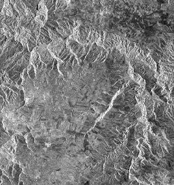 ...although a radar's side-looking geometry can result in several image effects such as foreshortening, layover, and shadow, this geometry is exactly what makes radar so useful for terrain analysis. These effects, if not too severe, actually enhance the visual appearance of relief and terrain structure, making radar imagery excellent for applications such as topographic mapping and identifying geologic structure.
![]()
![]()
| Updated 2002-11-27 | Important Notices |