Natural Resources Canada | Ressources naturelles CanadaGovernment of Canada | Gouvernement du Canada
FrançaisContact CCRSCCRS Site HelpSearch the CCRS WebsiteGovernment of Canada web site
Canada Centre for Remote SensingHome page of the Canada Centre for Remote SensingDetailed Listing of this SiteTechnical publications of CCRS staffExplanations of remote sensing terminology.Natural Resources Canada
Staff and organizationCCRS research programsImages and SensorsLearning aids and reference materialsThe Canadian remote sensing community

4. Image Analysis5. Applications
Table of Contents
1. Introduction
2. Sensors
3. Microwaves

Home > LearningTutorials

Fundamentals of Remote Sensing


Chapter 4


4.2 Whiz Quiz

Aerial photograph

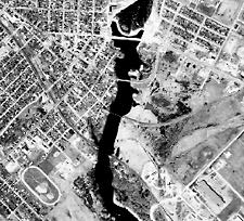
Take a look at the aerial photograph above. Identify the following features in the image and explain how you were able to do so based on the elements of visual interpretation described in this section.

  • race track
  • river
  • roads
  • bridges
  • residential area
  • dam

The answer is ...

Section 4.2 Did you know Section 4.3


Updated2002-08-21 go to top of page Important Notices