| Table of Contents |
| 1. Introduction 2. Sensors 3. Microwaves 4. Image Analysis 5. Applications |
Fundamentals of Remote Sensing
4.2 Whiz Quiz
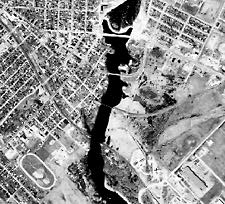
- The race track in the lower left of the image is quite easy to identify because of its characteristic shape.
- The river is also easy to identify due to its contrasting tone with the surrounding land and also due to its shape.
- The roads in the image are visible due to their shape (straight in many cases) and their generally bright tone contrasting against the other darker features.
- Bridges are identifiable based on their shape, tone, and association with the river - they cross it!
- Residential areas on the left hand side of the image and the upper right can be identified by the pattern that they make in conjunction with the roads. Individual houses and other buildings can also be identified as dark and light tones.
- The dam in the river at the top center of the image can be identified based on its contrasting tone with the dark river, its shape, and its association with the river - where else would a dam be!
![]()

![]()
| Updated2002-08-21 | Important Notices |