
| Table of Contents |
| 1. Introduction 2. Sensors 3. Microwaves 4. Image Analysis 5. Applications |
Fundamentals of Remote Sensing
5.2 Did You Know?
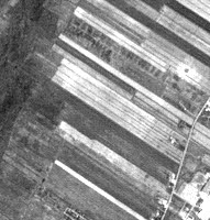
Fields in Quebec
Did you know that remote sensing of agricultural areas could give us clues about our heritage? In Québec, farmer's field shapes are very different than in Saskatchewan. In Québec, long thin strips of land extend from riverbanks, following French settlers' tradition. These types of fields are also visible in Nova Scotia, where the Acadians farmed, in New Brunswick, and in parts of Ontario. In the prairies, the fields are square and strictly follow the township and range plan.
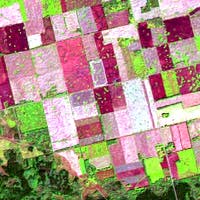
Fields in Saskatchewan
![]()

![]()
| Updated2002-08-21 | Important Notices |