
| Table of Contents |
| 1. Introduction 2. Sensors 3. Microwaves 4. Image Analysis 5. Applications |
Fundamentals of Remote Sensing
5.9.1 Answer
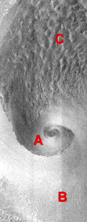
Imaged over the Labrador Sea, this RADARSAT image shows a number of 'imprints' made on the ocean surface by unusual atmospheric conditions. Though the radar beams themselves are not affected by the atmosphere, they have recorded the ocean topographic effects from atmospheric phenomena such as a large low pressure cell (A), atmospheric gravity waves (B) and a region of multiple rising/falling air currents (C). In each case, where the falling air mass dampens ocean waves, the radar backscatter is lessened, while the rising air mass induces surface wind, which in turn increases ocean waves and therefore, radar backscatter. Higher backscatter is shown in the imagery as brighter areas.
![]()
![]()
| Updated2002-08-21 | Important Notices |