| Table of Contents |
| 1. Introduction 2. Sensors 3. Microwaves 4. Image Analysis 5. Applications |
Fundamentals of Remote Sensing
2.3 Whiz Quiz - Answers
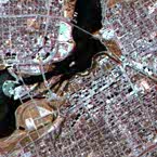
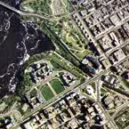
Answer 1: The image on the left is from a satellite while the image on the right is a photograph taken from an aircraft. The area covered in the image on the right is also covered in the image on the left, but this may be difficult to determine because the scales of the two images are much different. We are able to identify relatively small features (i.e. individual buildings) in the image on the right that are not discernible in the image on the left. Only general features such as street patterns, waterways, and bridges can be identified in the left-hand image. Because features appear larger in the image on the right and a particular measurement (eg. 1 cm) on the image represents a smaller true distance on the ground, this image is at a larger scale. It is an aerial photograph of the Parliament Buildings in Ottawa, Canada. The left-hand image is a satellite image of the city of Ottawa.
Back to the question...
Answer 2: A satellite sensor with large area coverage and fairly coarse spatial resolution would be excellent for monitoring the general state of vegetation health over Alberta, Saskatchewan, and Manitoba. The large east-to-west expanse would be best covered by a sensor with a wide swath and broad coverage. This would also imply that the spatial resolution of the sensor would be fairly coarse. However, fine detail would not really be necessary for monitoring a broad class including all vegetation cover. With broad areal coverage the revisit period would be shorter, increasing the opportunity for repeat coverage necessary for monitoring change. The frequent coverage would also allow for areas covered by clouds on one date, to be filled in by data collected from another date, reasonably close in time. The sensor would not necessarily require high spectral resolution, but would at a minimum, require channels in the visible and near-infrared regions of the spectrum. Vegetation generally has a low reflectance in the visible and a high reflectance in the near-infrared. The contrast in reflectance between these two regions assists in identifying vegetation cover.The magnitude of the reflected infrared energy is also an indication of vegetation health. A sensor on board the U.S. NOAA (National Oceanographic and Atmospheric Administration) series of satellites with exactly these types of characteristics is actually used for this type of monitoring over the entire surface of the Earth!
Back to the question...
![]()

![]()
| Updated2002-08-21 | Important Notices |