
| Table of Contents |
| 1. Introduction 2. Sensors 3. Microwaves 4. Image Analysis 5. Applications |
Fundamentals of Remote Sensing
5.3 Did You Know?
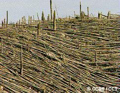
The forest around Mt. St. Helens after the eruption
Natural disasters can also wipe out huge areas of forest. Burns can destroy several thousand of hectares, landslides can displace trees down a slope, and excessive flooding can damage trees. Volcanoes however, have the greatest potential for destroying forests in the shortest amount of time. In 1980, Mt. St. Helens in northwestern United States violently erupted. The volcanic blast, reaching 320 km/hour, levelled over 600km2 of forest.
![]()

![]()
| Updated2002-08-21 | Important Notices |