
| Table of Contents |
| 1. Introduction 2. Sensors 3. Microwaves 4. Image Analysis |
|
5. Applications |
Fundamentals of Remote Sensing
5.3.1 Clear Cut Mapping & Deforestation
Background
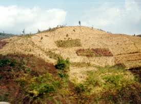
Deforestation is a global problem, with many implications. In industrialized Europe, pollution (acid rain, soot and chemicals from factory smoke plumes) has damaged a large percentage of forested land. In the former Czechoslovakia, one half of the forests are destroyed or damaged from pollutants. Similar effects are felt in Germany, Poland, and even the Scandinavian countries. In tropical countries, valuable rainforest is being destroyed in an effort to clear potentially valuable agricultural and pasture land. This has resulted in huge losses of tropical rainforest throughout Latin America (Central America, southern Mexico, Haiti), South America (Brazil), Africa and Asia. In both Haiti and Madagascar in particular, the results have been devastating. The loss of forests increases soil erosion, river siltation, and deposition, affecting navigation, fisheries, wildlife habitat, and drinking water supplies, as well as farming productivity and self-sufficiency.
Sensitive estuarine environments are protected by mangrove forest, which is cut or lost to urban growth, aquaculture, or damaged by pollutants or siltation. Monitoring the health of this forest is a step towards protecting the coastlines from erosion and degradation, and nearby inland areas from flooding.
The loss of forests also affects the genetic diversity of species on Earth, which controls our intrinsic ability to adapt to changing conditions and environment. Rainforests account for approximately one half of the plant and animal species on Earth, and destroying large sections will only serve to reduce the gene and species pool.
The rate and extent of deforestation, as well as monitoring regeneration, are the key parameters measured by remote sensing methods.
Why remote sensing?
Remote sensing brings together a multitude of tools to better analyze the scope and scale of the deforestation problem. Multitemporal data provides for change detection analyses. Images of earlier years are compared to recent scenes, to tangibly measure the differences in the sizes and extents of the clearcuts or loss of forest. Data from a variety of sources are used to provide complementary information. Radar, merged with optical data, can be used to efficiently monitor the status of existing clearcuts or emergence of new ones, and even assess regeneration condition. In countries where cutting is controlled and regulated, remote sensing serves as a monitoring tool to ensure companies are following cut guidelines and specifications.
High resolution data provide a detailed view of forest depletion, while radar can provide a view that may otherwise be obscured by clouds. All remote sensing devices, however, provide a view of often remote and inaccessible areas, where illegal cutting or damage could continue unnoticed for long periods of time if aerial surveillance wasn't possible.
Data requirements
Global monitoring initiatives, such as rain forest depletion studies, depend on large area coverage and data continuity, so it is important to use a sensor that will have successive generations launched and operational. Clear cut mapping and monitoring also require regional scale images and moderate or high resolution data depending on whether cuts are to be simply detected or delineated. As for many multi-temporal applications, a higher resolution image can be used to define the baseline, and coarser resolution images can be used to monitor changes to that baseline.
Canada vs. International
Optical sensors are still preferred for clear cut mapping and monitoring in Canada because forest vegetation, cuts, and regenerating vegetation have distinguishable spectral signatures, and optical sensors can collect sufficient cloud-free data.
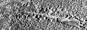
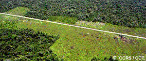
Comparison of photo (bottom)andSAR image (top)
of forest cuts along road.
Radar is more useful for applications in the humid tropics because its all weather imaging capability is valuable for monitoring all types of depletion, including clear cuts, in areas prone to cloudy conditions. Cuts can be defined on radar images because clear cuts produce less backscatter than the forest canopy, and forest edges are enhanced by shadow and bright backscatter. However, regenerating cuts are typically difficult to detect, as advanced regeneration and mature forest canopy are not separable. Mangrove forests generally occur in tropical coastal areas, which are prone to cloudy conditions, therefore a reliable monitoring tool is required to successively measure the rate of forest depletion. Radar has been proven to differentiate mangrove from other land covers, and some bands have long wavelengths capable of penetrating cloud and rain. The only limitation is in differentiating different mangrove species.
Case study (example)
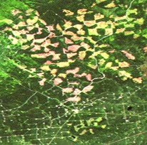 In Alberta, much of the province's forestland has been sold to offshore investors who are interested in selling pulp and paper products. Around the area of Whitecourt, clear cutting of conifer forest has been occurring for decades. In recent years however, the increasing demand for wood products has accelerated the cutting of the forests, resulting in a dissected and checkered landscape. Besides cutting for wood supply, forest depletion is also occurring due to cuts for seismic lines for oil and gas exploration and extraction. Both optical and radar sensors have been used to monitor the clear cuts and regeneration.
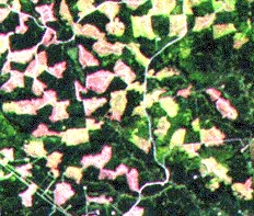
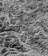
Optical and Radar scenes of forest clear cutting.
| Updated2002-08-21 | Important Notices |