
| Table of Contents |
| 1. Introduction 2. Sensors 3. Microwaves 4. Image Analysis 5. Applications |
Fundamentals of Remote Sensing
5.7 Answer
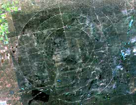
You had a good guess if you thought these circles were created by an ancient civilization, like the Aztecs, or it represents a giant teepee ring. But it's not correct. Try again.
The circles are part of a military base in southern Alberta. The land is used for practice maneuvers and is "protected" from the ranging and farming on nearby dry grassland. The circles identify radial distances from 'ground zero', where various real and simulated explosions were conducted by the military.
![]()

![]()
| Updated2002-08-21 | Important Notices |