
| Table of Contents |
| 1. Introduction 2. Sensors 3. Microwaves 4. Image Analysis |
|
5. Applications |
Fundamentals of Remote Sensing
5.6.2 Ice motion
Background
Ice moves quickly and sometimes unpredictably in response to ocean currents and wind. Ice floes can move like tectonic plates, sometimes breaking apart like a rift valley or colliding in a style similar to the Indian and Asian plates, creating a smaller version of the Himalayan Mountains - a series of ridges and blocky ice rubble. Vessels can be trapped or damaged by the pressure resulting from these moving ice floes. Even offshore structures can be damaged by the strength and momentum of moving ice. For these reasons it is important to understand the ice dynamics in areas of construction or in the vicinity of a shipping/fishing route.
Why remote sensing?
Remote sensing gives a tangible measure of direction and rate of ice movement through mapping and change detection techniques. Ice floes actually have individual morphological characteristics (shape, structures) that allow them to be distinguished from one another. The floes can be mapped and their movement monitored to facilitate in planning optimum shipping routes, to predict the effect of ice movement on standing structures (bridges, platforms).Users of this type of information include the shipping, fishing, and tourism industries, as well as engineers involved in offshore platform and bridge design and maintenance.
Data requirements
Monitoring of ice movement requires frequent and reliable imaging. The revisit interval must be frequent enough to follow identifiable features before tracking becomes difficult due to excessive movement or change in appearance. Active microwave sensing (radar) provides a reliable source of imaging under all weather and illumination conditions. RADARSAT provides this type of sensor and is a spaceborne platform, which is advantageous for routine imaging operations. The orbital path ensures that Arctic areas are covered daily which meets the requirement for frequent imaging.
The resolution and imaging frequency requirements for ice motion tracking vary with the size of floes and the ice dynamics in a region. In areas of large slow moving floes (e.g. Beaufort Sea), 1km resolution data over 10 day intervals is adequate. In dynamic marginal ice zones (e.g. Gulf of St. Lawrence), 100m resolution data over 12-24 hr intervals is required.
Case study (example)
The significance of the force and potential effect of ice movement was brought to light recently with the design and construction of the Confederation Bridge, a 13km link from Prince Edward Island, in Canada's Maritimes, across Northumberland Strait to New Brunswick on Canada's mainland. Crossing a strait that endures ice floes moving in response to winds, currents and tides through a narrow arm of the Gulf of St. Lawrence, the bridge will have to withstand tremendous forces from moving ice impacting its supports.
"More effort was spent related to the ice engineering aspect of this bridge than probably on any other [similar] structure that has ever been built" Dr. Gus Cammaert
Ice floes in Northumberland Strait are dynamic due to oceanic and atmospheric forces, yet constricted in their movement. The result is compression collisions creating large rubbly ice masses that extend vertically above and below the water level up to 20 m1 (each direction). These ice masses have the potential of critically damaging any structure impeding its movement back and forth in the strait. The design and engineering of the bridge had to take into account both the thickness and actual constant movement of the ice. Ice information archived at the Canadian Ice Service contributed to the understanding of the ice dynamics in the strait, and its tensile properties, critical for setting engineering parameters.
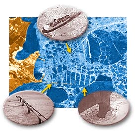
During construction, a radar image of the bridge site was obtained to observe the impact of the bridge supports on the flow of ice around the site. Due to the design of the supports, which are cone-shaped at the waterline to help bend and break the ice, the ice cracked and flowed around the supports. This is one image where ice movement can be inferred from a single image and does not require multi-temporal scenes. In the image, the ice can be seen flowing from bottom to the top with the wakes of rubble created by the bridge supports clearly visible.
Remote sensing will be used to monitor the effect of the bridge on the ice movement and ensure that ice build up isn't occurring beyond expectations. As exemplified in the image, the bridge will have an impact on the ice dynamics, by breaking up large floes into smaller pieces which may accumulate on the shore in piles. This effect will be monitored, as will any subsequent effects on microclimate, which might affect the agriculture or fishing industries of PEI1.
Bridge web site:
Reference: Thurston, H., 1997. Strait Across, Canadian Geographic, Vol. 117, No.2, March-April 1997.
For more information on ice applications:
Canadian Ice Service, Environment Canada: ![]() http://ice-glaces.ec.gc.ca/App/
http://ice-glaces.ec.gc.ca/App/
WsvPageDsp.cfm?ID=1&Lang=eng
![]()
![]()
| Updated2002-08-21 | Important Notices |