Natural Resources Canada | Ressources naturelles CanadaGovernment of Canada
Skip common menu bar (access key: Alt M)Skip institutional menu bar (access key: Alt 1)Skip all menu bars (access key: Alt 2)FrançaisContact CCRSCCRS Site HelpSearch the CCRS WebsiteGovernment of Canada web site
Canada Centre for Remote SensingHome page of the Canada Centre for Remote SensingDetailed Listing of this SiteTechnical publications of CCRS staffExplanations of remote sensing terminology.Natural Resources Canada
Staff and organizationCCRS research programsImages and SensorsLearning aids and reference materialsThe Canadian remote sensing community

Table of Contents
1. Introduction
2. Sensors
3. Microwaves
4. Image Analysis
5. Applications

Home > LearningTutorials

Fundamentals of Remote Sensing


Chapter 3


3.5 Did You Know?

"...rivers in the Sahara desert?...you're crazy!..."

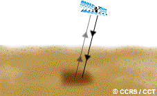
... that an L-band radar (23.5 cm wavelength) imaging from the orbiting space shuttle was able to discover ancient river channels beneath the Sahara Desert in Northern Africa. Because of the long wavelength and the extreme dryness of the sand, the radar was able to penetrate several metres below the desert surface to reveal the old river beds during ancient times when this area was not so dry.

back to Section 3.5 Whiz quiz 3.5 Section 3.6


Updated 2002-11-27 go to top of page Important Notices