Natural Resources Canada | Ressources naturelles CanadaGovernment of Canada
Skip common menu bar (access key: Alt M)Skip institutional menu bar (access key: Alt 1)Skip all menu bars (access key: Alt 2)FrançaisContact CCRSCCRS Site HelpSearch the CCRS WebsiteGovernment of Canada web site
Canada Centre for Remote SensingHome page of the Canada Centre for Remote SensingDetailed Listing of this SiteTechnical publications of CCRS staffExplanations of remote sensing terminology.Natural Resources Canada
Staff and organizationCCRS research programsImages and SensorsLearning aids and reference materialsThe Canadian remote sensing community

Table of Contents
1. Introduction
2. Sensors
3. Microwaves
4. Image Analysis
5. Applications

Home > LearningTutorials

Fundamentals of Remote Sensing


Chapter 3


3.5 Whiz Quiz

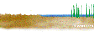
If an agricultural area, with crops such as wheat and corn, became flooded, what do you think these areas might look like on a radar image? Explain the reasons for your answers based on your knowledge of how radar energy interacts with a target.
The answer is ...

back to Section 3.5 Did you Know 3.5 Section 3.6


Updated 2002-11-27 go to top of page Important Notices