Natural Resources Canada | Ressources naturelles CanadaGovernment of Canada | Gouvernement du Canada
FrançaisContact CCRSCCRS Site HelpSearch the CCRS WebsiteGovernment of Canada web site
Canada Centre for Remote SensingHome page of the Canada Centre for Remote SensingDetailed Listing of this SiteTechnical publications of CCRS staffExplanations of remote sensing terminology.Natural Resources Canada
Staff and organizationCCRS research programsImages and SensorsLearning aids and reference materialsThe Canadian remote sensing community

Table of Contents
1. Introduction
2. Sensors
3. Microwaves
4. Image Analysis
5. Applications

Home > LearningTutorials

Fundamentals of Remote Sensing


Chapter 4


5.3 Whiz Quiz Answer

image of wells in the north of Alberta

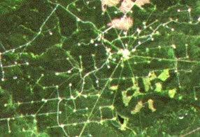
In northern Alberta, forests are being cut for pulp and paper mills, but they are also being cut for another reason. Exploration and infrastructure for gas wells requires that forests be cut for seismic lines, pipeline routing, access to sites, and pumping stations.

Back to the question...

Section 5.3 Did you know Section 5.3.1


Updated2002-08-21 go to top of page Important Notices