Fundamentals of Remote Sensing
2.7 Cameras and Aerial Photography
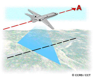
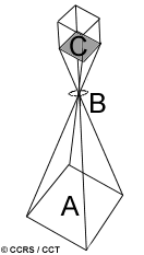 Cameras and their use for aerial photography are the simplest and oldest of sensors used for remote sensing of the Earth's surface. Cameras are framing systems which acquire a near-instantaneous "snapshot" of an area (A), of the surface. Camera systems are passive optical sensors that use a lens (B) (or system of lenses collectively referred to as the optics) to form an image at the focal plane (C), the plane at which an image is sharply defined.
Photographic films are sensitive to light from 0.3 mm to 0.9 mm in wavelength covering the ultraviolet (UV), visible, and near-infrared (NIR). Panchromatic films are sensitive to the UV and the visible portions of the spectrum. Panchromatic film produces black and white images and is the most common type of film used for aerial photography. UV photography also uses panchromatic film, but a filter is used with the camera to absorb and block the visible energy from reaching the film. As a result, only the UV reflectance from targets is recorded. UV photography is not widely used, because of the atmospheric scattering and absorption that occurs in this region of the spectrum. Black and white infrared photography uses film sensitive to the entire 0.3 to 0.9 mm wavelength range and is useful for detecting differences in vegetation cover, due to its sensitivity to IR reflectance.
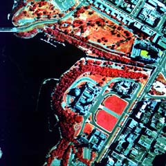
Colour and false colour (or colour infrared, CIR) photography involves the use of a three layer film with each layer sensitive to different ranges of light. For a normal colour photograph, the layers are sensitive to blue, green, and red light - the same as our eyes. These photos appear to us the same way that our eyes see the environment, as the colours resemble those which would appear to us as "normal" (i.e. trees appear green, etc.). In colour infrared (CIR) photography, the three emulsion layers are sensitive to green, red, and the photographic portion of near-infrared radiation, which are processed to appear as blue, green, and red, respectively. In a false colour photograph, targets with high near-infrared reflectance appear red, those with a high red reflectance appear green, and those with a high green reflectance appear blue, thus giving us a "false" presentation of the targets relative to the colour we normally perceive them to be.
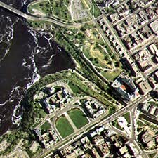
Cameras can be used on a variety of platforms including ground-based stages, helicopters, aircraft, and spacecraft. Very detailed photographs taken from aircraft are useful for many applications where identification of detail or small targets is required. The ground coverage of a photo depends on several factors, including the focal length of the lens, the platform altitude, and the format and size of the film. The focal length effectively controls the angular field of view of the lens (similar to the concept of instantaneous field of view discussed in section 2.3) and determines the area "seen" by the camera. Typical focal lengths used are 90mm, 210mm, and most commonly, 152mm. The longer the focal length, the smaller the area covered on the ground, but with greater detail (i.e. larger scale). The area covered also depends on the altitude of the platform. At high altitudes, a camera will "see" a larger area on the ground than at lower altitudes, but with reduced detail (i.e. smaller scale). Aerial photos can provide fine detail down to spatial resolutions of less than 50 cm. A photo's exact spatial resolution varies as a complex function of many factors which vary with each acquisition of data.
 Most aerial photographs are classified as either oblique or vertical, depending on the orientation of the camera relative to the ground during acquisition. Oblique aerial photographs are taken with the camera pointed to the side of the aircraft. High oblique photographs usually include the horizon while low oblique photographs do not. Oblique photographs can be useful for covering very large areas in a single image and for depicting terrain relief and scale. However, they are not widely used for mapping as distortions in scale from the foreground to the background preclude easy measurements of distance, area, and elevation.
Vertical photographs taken with a single-lens frame camera is the most common use of aerial photography for remote sensing and mapping purposes. These cameras are specifically built for capturing a rapid sequence of photographs while limiting geometric distortion. They are often linked with navigation systems onboard the aircraft platform, to allow for accurate geographic coordinates to be instantly assigned to each photograph. Most camera systems also include mechanisms which compensate for the effect of the aircraft motion relative to the ground, in order to limit distortion as much as possible.
 When obtaining vertical aerial photographs, the aircraft normally flies in a series of lines, each called a flight line. Photos are taken in rapid succession looking straight down at the ground, often with a 50-60 percent overlap (A) between successive photos. The overlap ensures total coverage along a flight line and also facilitates stereoscopic viewing. Successive photo pairs display the overlap region from different perspectives and can be viewed through a device called a stereoscope to see a three-dimensional view of the area, called a stereo model. Many applications of aerial photography use stereoscopic coverage and stereo viewing.
Aerial photographs are most useful when fine spatial detail is more critical than spectral information, as their spectral resolution is generally coarse when compared to data captured with electronic sensing devices. The geometry of vertical photographs is well understood and it is possible to make very accurate measurements from them, for a variety of different applications (geology, forestry, mapping, etc.). The science of making measurements from photographs is called photogrammetry and has been performed extensively since the very beginnings of aerial photography. Photos are most often interpreted manually by a human analyst (often viewed stereoscopically). They can also be scanned to create a digital image and then analyzed in a digital computer environment. In Chapter 4, we will discuss in greater detail, various methods (manually and by computer) for interpreting different types of remote sensing images.
Multiband photography uses multi-lens systems with different film-filter combinations to acquire photos simultaneously in a number of different spectral ranges. The advantage of these types of cameras is their ability to record reflected energy separately in discrete wavelength ranges, thus providing potentially better separation and identification of various features. However, simultaneous analysis of these multiple photographs can be problematic. Digital cameras, which record electromagnetic radiation electronically, differ significantly from their counterparts which use film. Instead of using film, digital cameras use a gridded array of silicon coated CCDs (charge-coupled devices) that individually respond to electromagnetic radiation. Energy reaching the surface of the CCDs causes the generation of an electronic charge which is proportional in magnitude to the "brightness" of the ground area. A digital number for each spectral band is assigned to each pixel based on the magnitude of the electronic charge. The digital format of the output image is amenable to digital analysis and archiving in a computer environment, as well as output as a hardcopy product similar to regular photos. Digital cameras also provide quicker turn-around for acquisition and retrieval of data and allow greater control of the spectral resolution. Although parameters vary, digital imaging systems are capable of collecting data with a spatial resolution of 0.3m, and with a spectral resolution of 0.012 mm to 0.3 mm. The size of the pixel arrays varies between systems, but typically ranges between 512 x 512 to 2048 x 2048.
![]()

![]()
| Updated2002-08-21 | Important Notices |