
Fundamentals of Remote Sensing
2.9 Thermal Imaging
Many multispectral (MSS) systems sense radiation in the thermal infrared as well as the visible and reflected infrared portions of the spectrum. However, remote sensing of energy emitted from the Earth's surface in the thermal infrared (3 mm to 15 mm) is different than the sensing of reflected energy. Thermal sensors use photo detectors sensitive to the direct contact of photons on their surface, to detect emitted thermal radiation. The detectors are cooled to temperatures close to absolute zero in order to limit their own thermal emissions. Thermal sensors essentially measure the surface temperature and thermal properties of targets.
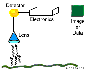
 Thermal imagers are typically across-track scanners (like those described in the previous section) that detect emitted radiation in only the thermal portion of the spectrum. Thermal sensors employ one or more internal temperature references for comparison with the detected radiation, so they can be related to absolute radiant temperature. The data are generally recorded on film and/or magnetic tape and the temperature resolution of current sensors can reach 0.1 °C. For analysis, an image of relative radiant temperatures (a thermogram) is depicted in grey levels, with warmer temperatures shown in light tones, and cooler temperatures in dark tones. Imagery which portrays relative temperature differences in their relative spatial locations are sufficient for most applications. Absolute temperature measurements may be calculated but require accurate calibration and measurement of the temperature references and detailed knowledge of the thermal properties of the target, geometric distortions, and radiometric effects.
Because of the relatively long wavelength of thermal radiation (compared to visible radiation), atmospheric scattering is minimal. However, absorption by atmospheric gases normally restricts thermal sensing to two specific regions - 3 to 5 mm and 8 to 14 mm. Because energy decreases as the wavelength increases, thermal sensors generally have large IFOVs to ensure that enough energy reaches the detector in order to make a reliable measurement. Therefore the spatial resolution of thermal sensors is usually fairly coarse, relative to the spatial resolution possible in the visible and reflected infrared. Thermal imagery can be acquired during the day or night (because the radiation is emitted not reflected) and is used for a variety of applications such as military reconnaissance, disaster management (forest fire mapping), and heat loss monitoring.
![]()

![]()
| Updated2002-08-21 | Important Notices |