Fundamentals of Remote Sensing
2.2 Satellite Characteristics: Orbits and Swaths
We learned in the previous section that remote sensing instruments can be placed on a variety of platforms to view and image targets. Although ground-based and aircraft platforms may be used, satellites provide a great deal of the remote sensing imagery commonly used today. Satellites have several unique characteristics which make them particularly useful for remote sensing of the Earth's surface.
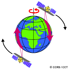
 The path followed by a satellite is referred to as its orbit. Satellite orbits are matched to the capability and objective of the sensor(s) they carry. Orbit selection can vary in terms of altitude (their height above the Earth's surface) and their orientation and rotation relative to the Earth. Satellites at very high altitudes, which view the same portion of the Earth's surface at all times have geostationary orbits. These geostationary satellites, at altitudes of approximately 36,000 kilometres, revolve at speeds which match the rotation of the Earth so they seem stationary, relative to the Earth's surface. This allows the satellites to observe and collect information continuously over specific areas. Weather and communications satellites commonly have these types of orbits. Due to their high altitude, some geostationary weather satellites can monitor weather and cloud patterns covering an entire hemisphere of the Earth.
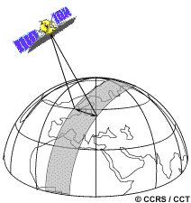
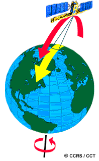 Many remote sensing platforms are designed to follow an orbit (basically north-south) which, in conjunction with the Earth's rotation (west-east), allows them to cover most of the Earth's surface over a certain period of time. These are near-polar orbits, so named for the inclination of the orbit relative to a line running between the North and South poles. Many of these satellite orbits are also sun-synchronous such that they cover each area of the world at a constant local time of day called local sun time. At any given latitude, the position of the sun in the sky as the satellite passes overhead will be the same within the same season. This ensures consistent illumination conditions when acquiring images in a specific season over successive years, or over a particular area over a series of days. This is an important factor for monitoring changes between images or for mosaicking adjacent images together, as they do not have to be corrected for different illumination conditions.
 Most of the remote sensing satellite platforms today are in near-polar orbits, which means that the satellite travels northwards on one side of the Earth and then toward the southern pole on the second half of its orbit. These are called ascending and descending passes, respectively. If the orbit is also sun-synchronous, the ascending pass is most likely on the shadowed side of the Earth while the descending pass is on the sunlit side. Sensors recording reflected solar energy only image the surface on a descending pass, when solar illumination is available. Active sensors which provide their
own illumination or passive sensors that record emitted (e.g. thermal) radiation can also image the surface on ascending passes.
Most of the remote sensing satellite platforms today are in near-polar orbits, which means that the satellite travels northwards on one side of the Earth and then toward the southern pole on the second half of its orbit. These are called ascending and descending passes, respectively. If the orbit is also sun-synchronous, the ascending pass is most likely on the shadowed side of the Earth while the descending pass is on the sunlit side. Sensors recording reflected solar energy only image the surface on a descending pass, when solar illumination is available. Active sensors which provide their
own illumination or passive sensors that record emitted (e.g. thermal) radiation can also image the surface on ascending passes.
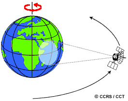
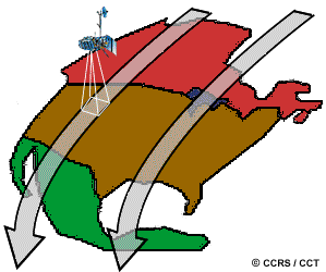
 As a satellite revolves around the Earth, the sensor "sees" a certain portion of the Earth's surface. The area imaged on the surface, is referred to as the swath. Imaging swaths for spaceborne sensors generally vary between tens and hundreds of kilometres wide. As the satellite orbits the Earth from pole to pole, its east-west position wouldn't change if the Earth didn't rotate. However, as seen from the Earth, it seems that the satellite is shifting westward because the Earth is rotating (from west to east) beneath it. This apparent movement allows the satellite swath to cover a new area with each consecutive pass. The satellite's orbit and the rotation of the Earth work together to allow complete coverage of the Earth's surface, after it has completed one complete cycle of orbits.
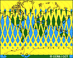
If we start with any randomly selected pass in a satellite's orbit, an orbit cycle will be completed when the satellite retraces its path, passing over the same point on the Earth's surface directly below the satellite (called the nadir point) for a second time. The exact length of time of the orbital cycle will vary with each satellite. The interval of time required for the satellite to complete its orbit cycle is not the same as the "revisit period". Using steerable sensors, an satellite-borne instrument can view an area (off-nadir) before and after the orbit passes over a target, thus making the 'revisit' time less than the orbit cycle time. The revisit period is an important consideration for a number of monitoring applications, especially when frequent imaging is required (for example, to monitor the spread of an oil spill, or the extent of flooding). In near-polar orbits, areas at high latitudes will be imaged more frequently than the equatorial zone due to the increasing overlap in adjacent swaths as the orbit paths come closer together near the poles.
![]()


![]()
| Updated2002-08-21 | Important Notices |