Fundamentals of Remote Sensing
2.10 Geometric Distortion in Imagery
Any remote sensing image, regardless of whether it is acquired by a multispectral scanner on board a satellite, a photographic system in an aircraft, or any other platform/sensor combination, will have various geometric distortions. This problem is inherent in remote sensing, as we attempt to accurately represent the three-dimensional surface of the Earth as a two-dimensional image. All remote sensing images are subject to some form of geometric distortions, depending on the manner in which the data are acquired. These errors may be due to a variety of factors, including one or more of the following, to name only a few:
- the perspective of the sensor optics,
- the motion of the scanning system,
- the motion and (in)stability of the platform,
- the platform altitude, attitude, and velocity,
- the terrain relief, and
- the curvature and rotation of the Earth.
Framing systems, such as cameras used for aerial photography, provide an instantaneous "snapshot" view of the Earth from directly overhead. The primary geometric distortion in vertical aerial photographs is due to relief displacement. Objects directly below the centre of the camera lens (i.e. at the nadir) will have only their tops visible, while all other objects will appear to lean away from the centre of the photo such that their tops and sides are visible. If the objects are tall or are far away from the centre of the photo, the distortion and positional error will be larger.
The geometry of along-track scanner imagery is similar to that of an aerial photograph for each scan line as each detector essentially takes a "snapshot" of each ground resolution cell. Geometric variations between lines are caused by random variations in platform altitude and attitude along the direction of flight.
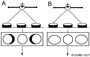 Images from across-track scanning systems exhibit two main types of geometric distortion. They too exhibit relief displacement (A), similar to aerial photographs, but in only one direction parallel to the direction of scan. There is no displacement directly below the sensor, at nadir. As the sensor scans across the swath, the top and side of objects are imaged and appear to lean away from the nadir point in each scan line. Again, the displacement increases, moving towards the edges of the swath. Another distortion (B) occurs due to the rotation of the scanning optics. As the sensor scans across each line, the distance from the sensor to the ground increases further away from the centre of the swath. Although the scanning mirror rotates at a constant speed, the IFOV of the sensor moves faster (relative to the ground) and scans a larger area as it moves closer to the edges. This effect results in the compression of image features at points away from the nadir and is called tangential scale distortion.
All images are susceptible to geometric distortions caused by variations in platform stability including changes in their speed, altitude, and attitude (angular orientation with respect to the ground) during data acquisition. These effects are most pronounced when using aircraft platforms and are alleviated to a large degree with the use of satellite platforms, as their orbits are relatively stable, particularly in relation to their distance from the Earth. However, the eastward rotation of the Earth,during a satellite orbit causes the sweep of scanning systems to cover an area slightly to the west of each previous scan. The resultant imagery is thus skewed across the image. This is known as skew distortion and is common in imagery obtained from satellite multispectral scanners.
The sources of geometric distortion and positional error vary with each specific situation, but are inherent in remote sensing imagery. In most instances, we may be able to remove, or at least reduce these errors but they must be taken into account in each instance before attempting to make measurements or extract further information.
Now that we have learned about some of the general characteristics of platforms and sensors, in the next sections we will look at some specific sensors (primarily satellite systems) operating in the visible and infrared portions of the spectrum.
![]()


![]()
| Updated2002-08-21 | Important Notices |