| Table of Contents |
| 1. Introduction 2. Sensors 3. Microwaves 4. Image Analysis 5. Applications |
Fundamentals of Remote Sensing
3.5 Whiz Quiz

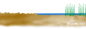
Generally, image brightness increases with increased moisture content. However, in the case of flooding, the surface is completely saturated and results in standing water. Areas where the water has risen above the height of the crops will likely appear dark in tone, as the water acts as a specular reflector bouncing the energy away from the radar sensor. Flooded areas would generally be distinguishable by a darker tone from the surrounding agricultural crops which are not flooded and would scatter more diffusely. However, if the wheat and corn stalks are not completely submersed, then these areas may actually appear brighter on the image. In this situation, specular reflections off the water which then bounce and hit the wheat and corn stalks may act like corner reflectors and return most of the incoming energy back to the radar. This would result in these areas appearing quite bright on the image. Thus, the degree of flooding and how much the crops are submersed will impact the appearance of the image.
Back to the question...
| Updated 2002-11-27 | Important Notices |
