
| Table of Contents |
| 1. Introduction 2. Sensors |
3. Microwaves |
| 4. Image Analysis 5. Applications |
Fundamentals of Remote Sensing
3.10 Airborne and Spaceborne Radar Systems
In order to more clearly illustrate the differences between airborne and spaceborne radars, we will briefly outline a few of the representative systems of each type, starting with airborne systems.
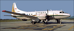
The Convair-580 C/X SAR system developed and operated by the Canada Centre for Remote Sensing was a workhorse for experimental research into advanced SAR applications in Canada and around the world, particularly in preparation for satellite-borne SARs. The system was transferred to Environment Canada in 1996 for use in oil spill research and other environmental applications. This system operates at two radar bands, C- (5.66 cm) and X- (3.24 cm). Cross-polarization data can be recorded simultaneously for both the C- and X-band channels, and the C-band system can be operated as a fully polarimetric radar. Imagery can be acquired at three different imaging geometries (nadir, narrow and wide swath modes) over a wide range of incidence angles (five degrees to almost 90 degrees). In addition to being a fully calibratable system for quantitative measurements, the system has a second antenna mounted on the aircraft fuselage to allow the C-band system to be operated as an interferometric radar.
 The Sea Ice and Terrain Assessment (STAR) systems operated by Intera Technologies Limited of Calgary, Alberta, Canada, (later Intermap Technologies ) were among the first SAR systems used commercially around the world. Both STAR-1 and STAR-2 operate at X-band (3.2 cm) with HH polarization in two different resolution modes. The swath coverage varies from 19 to 50 km, and the resolution from 5 to 18 m. They were primarily designed for monitoring sea ice (one of the key applications for radar, in Canada) and for terrain analysis. Radar's all-weather, day or night imaging capabilities are well-suited to monitoring ice in Canada's northern and coastal waters. STAR-1 was also the first SAR system to use on-board data processing and to offer real-time downlinking of data to surface stations.
 The United States National Aeronautics and Space Administration (NASA) has been at the forefront of multi-frequency, multi-polarization synthetic aperture radar research for many years. The Jet Propulsion Laboratory (JPL) in California has operated various advanced systems on contract for NASA. The AirSAR system is a C-, L-, and P-band advanced polarimetric SAR which can collect data for each of these bands at all possible combinations of horizontal and vertical transmit and receive polarizations (i.e. HH, HV, VH, and VV). Data from the AirSAR system can be fully calibrated to allow extraction of quantitative measurements of radar backscatter. Spatial resolution of the AirSAR system is on the order of 12 metres in both range and azimuth. Incidence angle ranges from zero degrees at nadir to about 70 degrees at the far range. This capability to collect multi-frequency, multi-polarization data over such a diverse range of incidence angles allows a wide variety of specialized research experiments to be carried out.
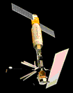 With the advances and success of airborne imaging radar, satellite radars were the next logical step to complement the optical satellite sensors in operation. SEASAT, launched in 1978, was the first civilian remote sensing satellite to carry a spaceborne SAR sensor. The SAR operated at L-band (23.5 cm) with HH polarization. The viewing geometry was fixed between nine and 15 degrees with a swath width of 100 km and a spatial resolution of 25 metres. This steep viewing geometry was designed primarily for observations of ocean and sea ice, but a great deal of imagery was also collected over land areas. However, the small incidence angles amplified foreshortening and layover effects over terrain with high relief, limiting its utility in these areas. Although the satellite was only operational for three months, it demonstrated the wealth of information (and the large volumes of data!) possible from a spaceborne radar.
 With the success of the short-lived SEASAT mission, and impetus provided from positive results with several airborne SARs, the European Space Agency (ESA) launched ERS-1 in July of 1991. ERS-1 carried on-board a radar altimeter, an infrared radiometer and microwave sounder, and a C-band (5.66 cm), active microwave instrument. This is a flexible instrument which can be operated as a scatterometer to measure reflectivity of the ocean surface, as well as ocean surface wind speed and direction. It can also operate as a synthetic aperture radar, collecting imagery over a 100 km swath over an incidence angle range of 20 to 26 degrees, at a resolution of approximately 30 metres. Polarization is vertical transmit and vertical receive (VV) which, combined with the fairly steep viewing angles, make ERS-1 particularly sensitive to surface roughness. The revisit period (or repeat cycle) of ERS-1 can be varied by adjusting the orbit, and has ranged from three to 168 days, depending on the mode of operation. Generally, the repeat cycle is about 35 days. A second satellite, ERS-2, was launched in April of 1995 and carries the same active microwave sensor as ERS-1. Designed primarily for ocean monitoring applications and research, ERS-1 provided the worldwide remote sensing community with the first wide-spread access to spaceborne SAR data. Imagery from both satellites has been used in a wide range of applications, over both ocean and land environments. Like SEASAT, the steep viewing angles limit their utility for some land applications due to geometry effects.
 The National Space Development Agency of Japan (NASDA), launched the JERS-1 satellite in February of 1992. In addition to carrying two optical sensors, JERS-1 has an L-band (23.5 cm) SAR operating at HH polarization. The swath width is approximately 75 km and spatial resolution is approximately 18 metres in both range and azimuth. The imaging geometry of JERS-1 is slightly shallower than either SEASAT or the ERS satellites, with the incidence angle at the middle of the swath being 35 degrees. Thus, JERS-1 images are slightly less susceptible to geometry and terrain effects. The longer L-band wavelength of JERS-1 allows some penetration of the radar energy through vegetation and other surface types.
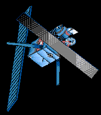
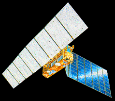
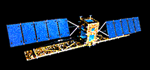 Spaceborne SAR remote sensing took a giant leap forward with the launch of Canada's RADARSAT satellite on Nov. 4, 1995. The RADARSAT project, led by the Canadian Space Agency (CSA), was built on the development of remote sensing technologies and applications work carried out by the Canada Centre for Remote Sensing (CCRS) since the 1970s. RADARSAT carries an advanced C-band (5.6 cm), HH-polarized SAR with a steerable radar beam allowing various imaging options over a 500 km range. Imaging swaths can be varied from 35 to 500 km in width, with resolutions from 10 to 100 metres. Viewing geometry is also flexible, with incidence angles ranging from less than 20 degrees to more than 50 degrees. Although the satellite's orbit repeat cycle is 24 days, the flexibility of the steerable radar beam gives RADARSAT the ability to image regions much more frequently and to address specific geographic requests for data acquisition. RADARSAT's orbit is optimized for frequent coverage of mid-latitude to polar regions, and is able to provide daily images of the entire Arctic region as well as view any part of Canada within three days. Even at equatorial latitudes, complete coverage can be obtained within six days using the widest swath of 500 km.
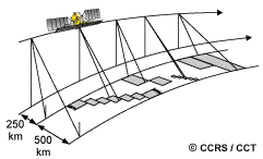
Imaging options over a 500 km range
![]()

![]()
| Updated 2002-11-27 | Important Notices |