
| Table of Contents |
| 1. Introduction 2. Sensors |
3. Microwaves |
| 4. Image Analysis 5. Applications |
Fundamentals of Remote Sensing
3.9 Airborne versus Spaceborne Radars
Like other remote sensing systems, an imaging radar sensor may be carried on either an airborne or spaceborne platform. Depending on the use of the prospective imagery, there are trade-offs between the two types of platforms. Regardless of the platform used, a significant advantage of using a Synthetic Aperture Radar (SAR) is that the spatial resolution is independent of platform altitude. Thus, fine resolution can be achieved from both airborne and spaceborne platforms.
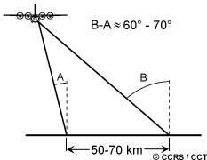
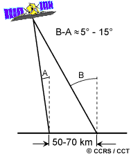
Although spatial resolution is independent of altitude, viewing geometry and swath coverage can be greatly affected by altitude variations. At aircraft operating altitudes, an airborne radar must image over a wide range of incidence angles, perhaps as much as 60 or 70 degrees, in order to achieve relatively wide swaths (let's say 50 to 70 km). As we have learned in the preceding sections, incidence angle (or look angle) has a significant effect on the backscatter from surface features and on their appearance on an image. Image characteristics such as foreshortening, layover, and shadowing will be subject to wide variations, across a large incidence angle range. Spaceborne radars are able to avoid some of these imaging geometry problems since they operate at altitudes up to one hundred times higher than airborne radars. At altitudes of several hundred kilometres, spaceborne radars can image comparable swath widths, but over a much narrower range of incidence angles, typically ranging from five to 15 degrees. This provides for more uniform illumination and reduces undesirable imaging variations across the swath due to viewing geometry.
Although airborne radar systems may be more susceptible to imaging geometry problems, they are flexible in their capability to collect data from different look angles and look directions. By optimizing the geometry for the particular terrain being imaged, or by acquiring imagery from more than one look direction, some of these effects may be reduced. Additionally, an airborne radar is able to collect data anywhere and at any time (as long as weather and flying conditions are acceptable!). A spaceborne radar does not have this degree of flexibility, as its viewing geometry and data acquisition schedule is controlled by the pattern of its orbit. However, satellite radars do have the advantage of being able to collect imagery more quickly over a larger area than an airborne radar, and provide consistent viewing geometry. The frequency of coverage may not be as often as that possible with an airborne platform, but depending on the orbit parameters, the viewing geometry flexibility, and the geographic area of interest, a spaceborne radar may have a revisit period as short as one day.
As with any aircraft, an airborne radar will be susceptible to variations in velocity and other motions of the aircraft as well as to environmental (weather) conditions. In order to avoid image artifacts or geometric positioning errors due to random variations in the motion of the aircraft, the radar system must use sophisticated navigation/positioning equipment and advanced image processing to compensate for these variations. Generally, this will be able to correct for all but the most severe variations in motion, such as significant air turbulence. Spaceborne radars are not affected by motion of this type. Indeed, the geometry of their orbits is usually very stable and their positions can be accurately calculated. However, geometric correction of imagery from spaceborne platforms must take into account other factors, such as the rotation and curvature of the Earth, to achieve proper geometric positioning of features on the surface.
![]()
![]()
| Updated 2002-11-27 | Important Notices |