
| Table of Contents |
| 1. Introduction 2. Sensors 3. Microwaves 4. Image Analysis |
|
5. Applications |
Fundamentals of Remote Sensing
5.8.3 Topographic & Baseline Thematic Mapping
Background
There is a growing demand for digital databases of topographic and thematic information to facilitate data integration and efficient updating of other spatially oriented data. Topographic maps consist of elevation contours and planimetric detail of varied scale, and serve as general base information for civilian and military use.
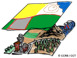 Baseline thematic mapping (BTM) is a digital integration of satellite imagery, land use, land cover, and topographic data to produce an "image map" with contour lines and vector planimetry information. This new concept of thematic mapping was developed to take advantage of improvements in digital processing and integration of spatial information, increased compatibility of multisource data sets, the wide use of geographic information systems to synthesize information and execute analyses customized for the user, and increased ability to present the data in cartographic form.
The data for baseline thematic maps are compiled from topographic, land cover, and infrastructure databases. Appropriate thematic information is superimposed on a base map, providing specific information for specific end users, such as resource managers. Various combinations of thematic information may be displayed to optimize the map information for application specific purposes, whether for land use allocation, utility site selection and route planning, watershed management, or natural resource management and operations.
Why remote sensing?
As a base map, imagery provides ancillary information to the extracted planimetric or thematic detail. Sensitivity to surface expression makes radar a useful tool for creating base maps and providing reconnaissance abilities for hydrocarbon and mineralogical companies involved in exploration activities. This is particularly true in remote northern regions, where vegetation cover does not mask the microtopography and generally, information may be sparse. Multispectral imagery is excellent for providing ancillary land cover information, such as forest cover. Supplementing the optical data with the topographic relief and textural nuance inherent in radar imagery can create an extremely useful image composite product for interpretation.
Data requirements
The prime data requirement is for high information content and a balance between resolution and data handling ability. There is a moderate turnaround requirement for this application; processed data should be available less than a year after imagery acquisition.
Canada vs. International
VIR imagery is excellent as a base map for planimetry detail on a varied landscape, providing information on forest, agriculture cover and gross geomorphology of the land. SAR is also good for providing surficial topographic expression.
Case study (example) BTM's in BC
(Baseline Thematic Mapping in British Columbia)
Baseline thematic mapping involves the compilation of varied data sources, ranging from satellite imagery to detailed forest stand information to planimetric data from the 1:250,000 National Topographic database. Base map sheets overlain by various combinations of thematic data are produced with an aim toward resource management applications. British Columbia's Ministry of Environment, Lands, and Parks routinely produces BTMs. The most recent Landsat TM data available is used as a source for classifications of ground cover and interpretation of land use. DEMs are also integrated into the satellite data to provide 3 dimensional perspective views. Although B.C. is quite advanced in this application, other Canadian provinces have contemplated or are doing similar work, as are private consultants in conjunction with forestry companies.
Baseline thematic mapping incorporates not only interpretations of ground cover data and land use, but topographic information such as elevation contours and planimetry to provide an optimal tool for resource management. This information may be portrayed in traditional map format, or as an image-map, which is an excellent means of presenting spatial data to resource managers and many other users.
![]()

![]()
| Updated2002-08-21 | Important Notices |